Distance: 30 miles


About
Overnight Route # 3 is a combination of routes #1 and #2, which begins at French’s Lake Coastal Access Kiosk, Holley Creek or Boatyard Lake Landings. Both of the latter locations are privately owned, but allow for public use in the form of fee associated boat launching and overnight vehicle parking. The map shows the trail begins in Majors Creek working its way to the old Alabama River channel. Day one ends at the Spoonbill Sandbar campsite. Day two proceeds down the Alabama River to Little Bear Creek, Bear Creek, Stiggins Lake and the Tensaw River. Day two ends at the Two-Rivers campsite. On day three the paddlers proceed down the Tensaw River and then into Bottle Creek, connecting to Bayou Jessamine, and then out to Rice Creek Landing after crossing the Tensaw River and Briar Lake.
Paddlers should note that Spoonbill Sandbar and Two-Rivers campsites are a first come, first serve land based campsites. These areas are large enough to handle several tents.
Habitats
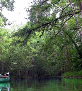
bottomland hardwood swamp, flowing creeks, side channel sloughs and backwaters
Ending Point
Campsites
Spoonbill Sandbar, Two Rivers Point
Type of trail
Old River Channel, Creek, Lake, and Slough
Recommended Water Levels
Claiborne Dam river stages ranging from 10 to 19 feet on tailrace readings provide optimum water levels for this route. Levels from 15-18 are the absolute best for the Globe and Bear Creek systems. For water level information at Claiborne Dam, call 1-888-771-4601 or visit https://waterdata.usgs.gov/al/nwis/uv?site_no=02428401