Distance: 7.25 Miles (additional miles possible via adjacent sloughs and creeks)


About
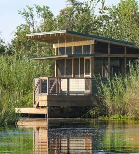
The Mudhole Creek Shelter is the northernmost camping shelter of the Lower Bartram Canoe Trail. This shelter sits just above the surface of the water and is located approximately 1.25 miles from the mouth of Mudhole Creek. This shelter faces Northeast and provides a secluded view of the Mobile-Tensaw Delta ecosystem. The Mudhole Creek shelter provides ample room for 6 people and has a porch area outside of the main screened area with room for a few chairs. The shelter includes a fixed dock for loading and unloading, a cooking table, benches, eye hooks for hammocks, and a curtained privacy area located in the corner of the shelter.
Camping Shelter Use Rules:
◦When camping in shelters group size is limited to 8.
◦Pets are not allowed in Shelters.
◦No open fires within 20ft of shelters. Cooking stoves (propane only) are allowed on shelter porches.
◦No cutting of trees or brush for firewood.
◦Each party is required to have a compass, map, flashlight, and portable toilet with disposable bags.
◦Shelters can be reserved for only one night. A group can reserve shelters at different locations when taking multiple night trips. Reservations are from 12 noon to 12 noon the following day. Must have a copy of shelter reservation on person.
◦Feeding or harassing of wildlife is prohibited. Do not discard garbage or food scraps on or near shelters.
◦Shelters will be inspected after each use. Damage to the shelters will be assessed and be the responsibility of the user.
◦Visitors may be held financially responsible for unnecessary rescues.
◦No alcohol allowed.
Habitats
Brackish marsh influenced by river flows from the north and by tides from Mobile Bay to the south. Except for occasional cypress stands, this area is largely without tall trees. Expansive marshes shelter a great number of species of fish, crustaceans, marsh and wading birds, flood-tolerant mammals, reptiles, etc. Please beware of Alligators as they are known to inhabit this area.
Starting Point
Ending Point
Type of trail
River Channel, Slough, Marsh Channels
Recommended Water Levels
The Mudhole Creek shelter is typically not impacted by high or low water, but extreme water levels may impact the navigability into and out of the fixed shelter dock. Claiborne Dam river stages ranging from 6 to 19 feet on tailrace reading provide optimum water levels for this route. River stages above these values should be considered hazardous. For water level information at Claiborne Dam, call 1-888-771-4601 or visit https://waterdata.usgs.gov/al/nwis/uv?site_no=02428401