Distance: 21.3 Miles


About
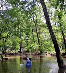
This multiple night trail would require the reservation of Canal Island and Dead Lake Island floating platform campsites. The map shows this route leaving French’s Lake Coastal Access Kiosk. The trail begins in Majors Creek working its way down Globe Creek, into Big Beaver Creek and Little Lake. Day one ends on the floating campsite located on the east side of Canal Island. On day two the paddlers explore Stiggins Lake, the Tensaw River and Bayou Tallapoosa. Day two ends on the floating campsite in the slough located on the west side of Dead Lake Island. On day three the paddlers travel up Tensaw Lake to Upper Bryant Landing.
Habitats
old river channel, bottomland hardwood swamp, flowing creeks, side channel sloughs and backwaters
Ending Point
Campsites
Canal/Dead Lake Island
Type of trail
River, Creek, Lake, and Slough
Recommended Water Levels
Claiborne Dam river stages ranging from 10 to 19 feet on tailrace reading provide optimum water levels for this route. Levels from 15-18 are the absolute best for the Globe and Bear Creek systems. For water level information at Claiborne Dam, call 1-888-771-4601 or visit https://waterdata.usgs.gov/al/nwis/uv?site_no=02428401