Distance: 13 miles


About
The map shows the Jug Lake trail paddling Rice Creek into Briar Lake on the east side of Larry Island. The trail proceeds to the west side of Larry Island into Tensaw Lake / Tensaw River and down to Bayou Jessamine ending at the platform campsite located in Jug Lake. Day two returns to the Tensaw River via Bayou Jessamine and back up Briar Lake to Rice Creek.
Habitats
old river channel, bottomland hardwood swamp, flowing creeks, side channel sloughs and backwaters
Starting Point
Ending Point
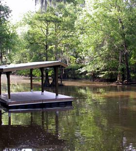
Campsites
Jug Lake
Type of trail
River, Creek, Lake, and Slough
Recommended Water Levels
Claiborne Dam river stages ranging from 6 to 19 feet on tailrace reading provide optimum water levels for this route. River stages above these values should be considered hazardous. For water level information at Claiborne Dam, call 1-888-771-4601 or visit https://waterdata.usgs.gov/al/nwis/uv?site_no=02428401