Distance: 7 Miles (additional miles possible via adjacent sloughs and creeks)


About
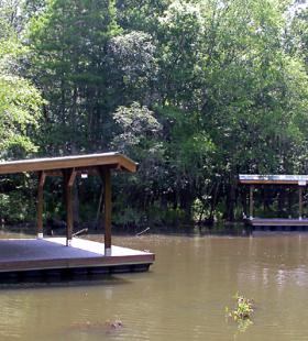
The Dead Lake Island campsite has two floating platforms to accommodate larger groups. If your group is larger than eight the reservation of both platform campsites is required. The map shows the Dead Lake Island trail leaving Upper Bryant’s Landing paddling west on Tensaw Lake. Day one ends at the floating platform located in the slough west of Dead Lake Island. The return route is the same. The paddlers have the option of exploring the side creeks and sloughs as well as Tallapoosa Bayou.
Habitats
bottomland hardwood swamp, side channel sloughs and backwaters
Starting Point
Ending Point
Campsites
Dead Lake Island
Type of trail
Bottomland Hardwood Swamp, Side Channel Sloughs and Backwaters
Recommended Water Levels
Claiborne Dam river stages ranging from 6 to 19 feet on tailrace reading provide optimum water levels for this route. River stages above these values should be considered hazardous. For water level information at Claiborne Dam, call 1-888-771-4601 or visit https://waterdata.usgs.gov/al/nwis/uv?site_no=02428401